|
Storms
are dangerous. They can kill and they often do. This is not a
general description of storms but a few selected topics from
wartime flying, gliding, some background philosophy and some
personal experience. Maybe some lessons for the thoughtful.
There
is a monument at the entrance to
Carnarvon
National Park
- an aircraft wing standing upright. It is from an American
aircraft - metal as we use today - that was wrecked by a storm
on a simple cross country flight in our outback. All killed.
And such an aircraft would have a higher
strength than, say, a 747: That is, put rather crudely,
a higher G load to structural failure. Be it a Spitfire, a
glider, a modern airliner - storms can always win.
They often do.
Storms
are simply one aspect of weather and as such should not be too
separated from our understanding of weather generally. Storms
can be forecast - or mostly they can be - but forecasting can
be imprecise or faulty, or simply unavailable. Nothing can
replace experience but we cannot always decide upon the
experience we should have. Storms themselves vary. They can be
isolated, in lines, associated with weather patterns,
triggered by physical features, be the so called dry
variety, spawn tornadoes, have low cloud associations or show
surprisingly little cloud, vary in colour leading up to the
terrible brown storms, have associated with them the smoothest
of lift or be turbulent to structural failure, have invisible
(or wonderfully visible) rolls - and so we could go on.
Storm
characteristics do vary with the part of the world we are in.
If we take the gliding area west of the Divide from The
Downs to
Victoria
we can certainly
have storms but they are not normally a real worry to the wary
glider pilot. Go further west and north into the tropical or
monsoon area and we have - well - the monument at the park
entrance. There are of course storms in
England
and
Europe
and they can be
severe but usually they are not in comparison with elsewhere.
During the war there was the incredible effective ( from our
point of view) firestorm series of bombing raids on
Hamburg
. Potential for storms. Potential for firestorms from
concentrated bombing as
at
Hamburg
and later,
Dresden
. First night at
Hamburg
and conditions suited the bombers. Next night the storms
played merry hell with the aircraft but not quite, in most
cases, to the structural failure stage. And, it is said,
storms were only to about 20,000 feet. Babies, in comparison
with the 80,000 plus heights of elsewhere. If we move to
USA
we now see on TV the terrible storms and lightning and
tornadoes they
have in the central west. I will save the Asian monsoons for
later.
For
an understanding of storms a pilot needs theoretical knowledge
of storm formation and structure - an understanding of lapse
rate - of the dry adiabatic lapse rate - of condensation
level- of weather pattern movement. Then of course for the
storm itself we have ice, hail, lightning. Updraft and
downdraft. The smooth outflow and lift area, turbulent areas,
the roll area or cloud. But all this should fit into a general
weather knowledge. Limited knowledge can be dangerous.
The
fortunate pilot is introduced to storms gradually - later,
actually, after a knowledge and appreciation of weather has
already been built up. Luck of the draw in a way - and I made
a very lucky and interesting draw. Let me expand. I began by
doing over a year of training in roughly what I have described
as the gliding area. As it was training many weather decisions
were made for me and as I gained training experience I was
exposed to more and more weather. But rather soft weather.
Then the move to
England
and another year or more of further training and actual first
pilot experience. A vastly different type of weather that
introduced me to bad weather flying but not really of the
storm type. A background weather experience that served as a
suitable introduction for what was to come later.
Let
me leave storms for a while, and
move to the pilot. A pilot of course needs training and
experience. Training is not experience - experience comes
later: But in most cases even experience has its limitations.
And the weather in which a pilot flies has its patterns quite
apart from what we might call the regular
local climatic patterns. But let us move to real life.
And a few
comparisons or stories.
Waikerie
South
Australia
. World competition glider pilots. One from
England
. In conversation he mentioned - the village to the east about
twelve miles away. Twelve miles? No - it was about forty. He
was judging with his very extensive English flying experience.
But dont let us only pick on the Poms. Wartime. Wartime
trained pilots with eight full months of
training. Air Force pilots with wings. Air Force
training - not Saturday afternoon flying. On a number of
occasions I would have my little joke with them when as
instructor I would take them up on their first (air
experience) flight in
England
. A look at the English countryside. Experiencing a new
aircraft type. A typical very hazy English day. Almost a fun
flight. I would end them up on the downwind leg with the aerodrome
in position on their side - correct heading - correct height.
Then tell them -
right, were in the circuit. You try the landing. Quite
often they simply could not see the airport. There it
was large as life and their unaccustomed eyes could not
see it through the incredible complexity of the English
countryside after the sparse easy to follow Australian
countryside. But in no time flat they would be quite at home
flying in
England
.
These
pilots were not over-confident - exactly the opposite. English
countryside was a new and surprising experience - the
countryside and the poor hazy
visibility. Overconfidence even when combined with training
and experience can be another aspect. A thousand hours of
flying in
England
with its confused countryside, its smoggy conditions when on
occasions the ground becomes invisible from 3000 feet, its low
cloud base of a hundred feet. Then to
India
- what are these local pilots on about with weather after
English weather? The pilot I am thinking about (and it was not
me) did not take long to learn.
Another
aspect before we get back to our storms. There is a certain
in between condition when
we consider area climate and short time
associated weather variability. We can have what I will
call periodic weather. A dry spell of quite a few years. Wet
periods.
In
the sixties we had a number of successive years with specific
storm conditions over the
Downs
and the South-East. Doubtless even beyond as well. As summer
approached the weather was often stormy. Afternoon, fairly
scattered isolated
or line storms. We learned certain habits. Watch things
on cross country flights but some very interesting cross
country flights were still possible. Carry on with the
training circuits but be ready to pack up quickly and get the
gliders hangared. For an hour or so at least. We developed a
safety procedure. Most storms were pretty obvious -
nothing unusual about that - but I can recall two days when we
had what I will call dry storms. The weather change was there
to see but - well,
it didnt really look like a storm. But on two occasions a
glider doing a circuit suddenly found it was being blown
down wind and simply could not complete its circuits. Blown
away before the storm and luckily, in both cases to a
paddock landing a few miles away. But more detail on those
flights shortly.
And
something else too. When to pack up and hanger the gliders?
I recall once at Oakey when
Daphne and I were flying the Hutter privately and the
Oakey Club were doing club flying. Yes, storms about but not
yet time to pack up. Or was it?
Local knowledge told the Club members that a certain
storm would miss the aerodrome.
But they were neglecting one recently published bit of
knowledge. I knew of it and put the Hutter away. They
continued to rely on their local experience and as a
result had their glider damaged trying to get it off the field
and into the hanger when
the storm did pass over the aerodrome itself.
My extra piece of knowledge came as a result of a
series of experiments carried out by the Met section of the
Department of Civil Aviation - storm experiments on the
Darling Downs. I will move on to that too
but one final bit of general comment.
The
sixties moved on and the stormy
weather cycle moved on too. A new generation of glider pilots
grew up who had little storm experience and almost
laughed at us old timers who warned of a storm danger when we
saw such a danger as a possibility. The new pilots had
to learn the lessons for themselves. I dont recall saying
though - Told you so. What is that background word so
important in the education of a pilot? - AIRMANSHIP - a broad
and very important concept. Anyway, lets move to the Downs
Weather experiments. That will get us back to storms
themselves. Glider weather first and wartime later.
Gliding
Weather:
It
could be a good day. Isolated fair weather Cu or better still,
maybe it could be streets of these Cu. Maybe very smooth -
perhaps a little rough. Depending on the lapse rate picture we
could also have towering Cu. Not thunderstorms but tops at
12, maybe 15, maybe even over 30,000. Again, smooth or
rough but this
not specifically related to height.
Turbulence can vary. I can recall one fantastic day
approaching Narromine from the north where I took only about
every third thermal, one turn and I was centered on smooth
1000fpm lift. And the opposite - again in the clear - when I
could demonstrate to a pupil how almost ineffective the
controls could become under a good Cu - and of course worse if
we had illegally gone in. There can be terrible turbulence in
a Cu at, say, 12000. But again, I can recall a climb in a
towering Cu near Inverell where the lift was smooth. And
powerful. I had elected to come out at about 20,000 and turned
on to my pre planned escape heading. I gained another 3000 on
the way out and saw the tops were over 30,000. Why not go
higher? Basically then there were two types of oxygen masks. I
did not have the better type recommended for 30,000 and
above. But we are really concerned here with storms. Storms
can look bad but they can also be deceptive in appearance. I
will recount now an extract from a write-up I did in the
sixties. It was called Sailplane Meteorology -- without tears.
Late
evening storms had been forecast. Throughout the day, although
there had been an abundance of ragged Cu, lift had been very
weak. Even the Grunau, which can usually stay up on a puff,
managed only a bare twenty minutes. The ground was very wet
from almost a week of rain.
About
4pm the Hutter was launched, after the Kookaburra had done a
circuit without contacting lift. Those at the aircraft end
noticed a heavy cloud to the left with a misty scud in
turbulent movement well below the main cloud base. Those at
the winch saw the pilot contact lift to the right near a
similar but separate cloud. It soon became obvious to them
that the pilot was having great difficulty controlling the
aircraft. About this time those at the winch end heard a sound
like rain and saw trees and corn in the distance in violent
agitation. Soon the wind (for wind it was and not rain)
arrived. It blew at 25-30 mph almost down wind compared with
the launch direction. This immediately and effectively stopped
launching. Meanwhile the Hutter got further and further away
and eventually was seen to make an approach into a paddock
about four miles from the strip. To this time there had been
no thunder, lightning or rain. Within the next hour small
isolated storms passed through the district in fairly rapid
succession, but no rain fell on the aerodrome or where the
glider had landed.
Another
time. The sailplane pilot reported smooth and increasing lift
off the launch. This lift suddenly became turbulent and scuds
were noticed forming at the sailplane height of about 2000
feet. Turbulence became so severe the pilot was barely able to
maintain control.. The g meter, fitted as a permanent
instrument to this aircraft, fluctuated between -1.5 and +3 g;
dust remained suspended before the pilots eyes. He noticed
the strong wind change and turned down wind out of the
turbulence, drifting rapidly away from the field. Several
later attempts to return again produced severe turbulence and
it became a case of getting down somewhere in a paddock. This
sailplane was not equipped with spoilers and the pilot found
himself in the unusual position of being unable to lose height
even with as much speed on the clock as he dared.
Paddock after paddock disappeared beneath him, and
after quite a few beats across wind at 800 feet, a safe
landing was made. The
pilot reported it was his most frightening flight ever. ( I
was not the pilot on any of these flights!)
Next
day, at about 1.30 pm three heavy storms could be seen from
the field. The Grunau was soaring and as one storm seemed to
be approaching the aerodrome all aircraft except the
Kookaburra were hangared. Very heavy rain looked 6-8 miles
away when the wind changed, thus preventing the launch of the
Kookaburra. The Grunau at this time was about 1500 over the
strip. It lost height slowly and looked to those on the ground
to be setting up for a normal circuit, which would have
meant a 25 mph downwind landing. At about 300 feet he made a
change of direction and even though it was obvious to those on
the ground control was difficult, he made a safe landing into
wind. The pilot
reported that at first he thought
he had found a smooth evening thermal but turbulence,
when it came, had him afraid of structural failure. His
concern was to try to get down safely - anywhere.
On
another occasion the Kookaburra launched with a storm nearby.
Those on the ground noticed a strange wind change when the
plane was about 200 feet. The pilot reported a normal launch
into lift and an immediate climb to 3000 feet. The previously
smooth lift then became turbulent. He applied spoilers, lost
height rapidly, and landed safely in the strong wind period to
the commencement of heavy rain.
These
few years of peculiar storm conditions passed and as I said
earlier, later pilots 'poo-hooed' advice of the lessons
learned. What are the lessons? Let us look now at what I will
call - The Anatomy of Thunder Storms.
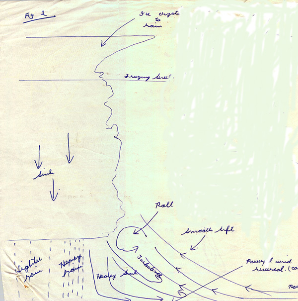
Our
representative storm cell has grown out of a towering cumulus
cloud with its cauliflower top. An anvil blows out ahead of it
at the top gradually shading the area ahead. The whole cell
moves across the countryside blown by a lower but also upper
wind. It has grown well above freezing level which will vary
mainly with latitude but also with atmospheric conditions. On
the Darling Downs it will often be about 12,000 feet. There
will be a strong area of lift inside the cloud itself and
behind that a downdraft area. The updraft and downdraft will
be essentially side by side. In
India
we were quoted possible speeds of 100 mph. I have seen that
figure corrected after later post war research. Two hundred
miles per hour was given.
On
the ground ahead of the cell the wind will often be light
blowing towards
the cell. Thus aircraft can be taking off into a light wind
flying away from the storm. Suddenly though there will arrive
an extremely powerful and turbulent downdraft wind ahead of
the cell. A wind reversal as far as the pilot is concerned.
Just ahead of the cloud itself at about cloud base these two
opposing winds can form a roll. Though usually invisible at
times it can appear as a most spectacular roll cloud. And this
- visible or otherwise- can
be catastrophic for a pilot. Once a pilot has actually
seen a roll cloud he needs no further advice on the dangers
near storms.
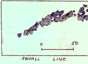
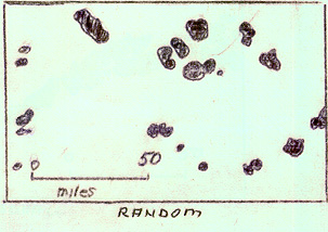
The
diagrams that follow are from notes written in the sixties -
line drawings from research information - and obviously before
the days of electronic reproduction.
|
|
|
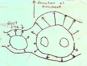
The
diagram on the left shows part of a squall line, as opposed to
a single cell, with the wind direction shown.
The first gust line preceding a line of storms may
extend for many tens of miles without a break.
|
|
|
|
Radar
picks up cells from which rain is falling.
The two diagrams
below show actual radar echoes for a squall line and random
storms ...
Recent
investigations were made into storms on the Darling Downs by
the meteorological Office, Brisbane. While it would be unwise to apply the findings as is
to all areas, many findings will hold good as a general rule.
Of about 100 storms studied, one fifth occurred in
general rain conditions and as such would not normally affect
the sailplane pilot. One fifth had short paths of less than 20
miles, but about
half had paths of more than 20 miles.
Locals
will often say, "our storms come from that direction" or
"any storm you
see there wont come here". The Darling Downs investigation showed
that almost all of the 100 storms studied did come from a
certain 120 degrees of the compass (in this case 180 to 300
degrees).
The investigators were naturally reluctant to draw
definite conclusions from such a short series and they did
draw attention to the fact
that ground estimates of paths are frequently
unreliable. An attempt was made to relate storm movement to an
upper wind level. In work done in
Florida
in 1949 over 95% of storm movement agreed with the 12,000 foot
wind. Agreement on the Downs with winds at
Brisbane
(nearest available) also
gave a high agreement but at a lower percentage with the
10-15,000 foot wind. Speed of storm movement was slower than
the wind speed.
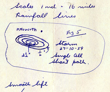
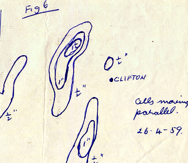
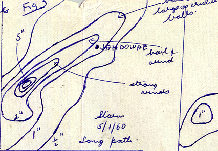
From
the rainfall results of actual
random type storms it appears most are 4-10 miles wide. This
points to the fact a glider may be able to make a safe landing
to one side of the storm. In the figures below, rainfall
results show the extent and path of random storms. Gliders
could be doing cross country flying in such storm conditions.
Obviously a storm may consist of more than one cell. A number
of cells may form one large cloud and the life of the cloud
may be prolonged, with each cell having a life of about half
an hour.
While
people usually associate the arrival of a storm with the
commencement of heavy rain, the storm has arrived, as far as
the sailplane pilot is concerned, four to ten miles ahead of
this, and 15 to 20 minutes before.
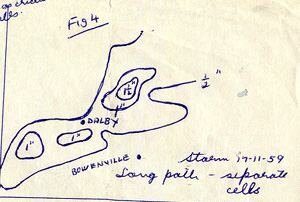
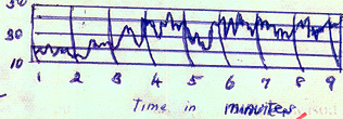
 |
| Smooth lift is experienced
at height before those on the ground become aware of the wind
change. When lift is experienced the ground is often in full
shadow. Because of the cell cycle danger can exist well before
the advent of thunder or lightning. It is repeating the
obvious to say that the roll area is a source of high danger
whether it is cloud visible or not. |
|
|
|
|
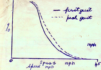
The
wind reversal, when it comes, can be sudden and strong. Ground
handling is difficult. The diagrams
emphasise the first gust danger and its severity.
|
|
I will conclude this section with some extra findings of the
Darling Downs storm observations. During a 127 day period there were
56 storm days. Of these 32 were line storms, 6 were along
surface fronts, 19 were ahead of surface cold fronts and 7
apparently had no connection
with surface fronts. In the squall line zone ahead of
the cold front, several roughly parallel lines of storms were
observed, although it was not found possible to distinguish
the lines from the ordinary synoptic weather charts. The lines
examined had an average length of over 100 miles and were 36
miles wide. The squall line is not always parallel to the
front line and of the cases examined varied up to 60 degrees
from the front line. The
squall line may persist for up to 24 hours and move hundreds
of miles in that time. The squall lines consist of cells as
described previously.
But
let us leave peace time Australia
now and go back to the World War II period.
Wartime
Weather:
Of course there are storms in
England
and
Europe
. On very rare occasions
England
can have a tornado. But I will put English bad weather
into context this way. After the initial shock of experiencing
average English weather after the nice Australian
weather we trained in, many of us grew almost to like the poor
visibility hazy days. Those of us involved with Beam
instruction (landing in low cloud conditions using radio beam
systems ) literally rubbed our hands in glee when we struck a
real day with a cloud base of 100 feet. But after
falling in love almost, with
the bad but soft English weather we entered a new world with
the weather of
India
and
Burma.
Almost
a thousand hours of wartime
England
first pilot. Flying a Mosquito from
England
, across North Africa, and into
Asia. Then the initial Squadron
briefing at Calcutta. Forget about previous weather experience. Soon, it will be
the monsoon. Rain youve never experienced. Well, yes, very
heavy. It will take the paint off your aircraft. And peel the
fabric cover over the under wing top surface. But that will
not be the real worry. There will be storms. Long lines along
the coasts you will have to cross going and coming - Burma,
the Malay Peninsula. And other storms as you fly over Siam
and perhaps China (no storm detecting radar in those days.)
You enjoy cloud flying? Well here you stay out of cloud if at
all possible. Your aircraft that will take you easily to
40,000 feet wont get you over them and will break up in
them.
We
were told we would not be able to tell the difference between
blue sky and black cloud. Maybe, we thought but it was right
and it did happen to me. I was pretty sure it was a clear
space in the distance to use but no - it WAS black cloud ...
and
worse still, we were told, was the brown storm. Later I was to
agree with that. We were also told of the Spitfire pilot who
entered a storm and found himself in his seat with no aircraft
round him. He did parachute
down OK, we were told. A good story we felt, and obviously
embellished to impress. More on that story later.
So
the monsoon came and so did the weather and the storms. I will
quote now a number of extracts from my wartime write-up -
"This
Mans War".
19/4/45
... I noted in my diary: F\Lt........... did not arrive
from Coxs. They searched with
the Harvard in the morning. We are on tomorrow. We flew low as
prescribed searching, two miles south of track but no sign.
Time for a swim. The
Squadron was based at Alipore, Calcutta
. After a briefing we would take off some time after lunch and
fly to an aerodrome on the coast to be ready for a trip (an op
as it was called) the next day. We used a forward base, and
this shifted forward as we gained ground against the
Japs. At this time we used Coxs Bazaar, in present
day
Bangladesh
. If we were early enough we could go for a swim in the
Bay of Bengal
. We would fly our op
and, after refuelling, would return to Alipore. This out and
return section was across the Sundabans, the 300 mile wide
delta of the Ganges and Bramaputra Rivers - flat, swampy,
mangrove covered, settled in a few isolated spots. We each got
to know certain islands and spots on track on this run. By
this time - April - storms were beginning to worry us - make
us alter course to avoid them.
20/4/45
... again from my diary: No. 9. Off just after six. There was
a little stratus on the way. It was clear over
Bangkok
for the bomb damage assessment. The Liberators had paid
Bangkok
a visit the day before. Smoke rising but got
Bangkok
OK
. Then we followed a
canal, photographing it, and
also took a bridge for BDA. No
good for mapping survey. We took coverage for map making which
had to be in the clear from 25,000 feet. Saw what looked like
a dump and took it from 9500. Alto-stratus clouded over 10/10.
It was 10/10 then, not 8/8 as now. Time 6.50.
After
refuelling at Coxs,
I flew back to Alipore with the weather very stormy
indeed. Very stormy indeed
was quite an understatement. It was one of those
brown storms we had been warned about. Hell, it looked
terrible, and right on our track. I deviated east and flew around
it.
Next
I got involved in flying the C.O. to
Kashmir
for leave. I was one of the second dickies. That took a couple
of days. Meantime the wreck of the missing plane had been
found. There is a common saying for someone who is exactly on
track - dead on track. Unfortunately it was for real this
time. It was on a mangrove island that had a particular shape
and one some of us used to check our track.
29/4/45: I did an
op to
Southern China
flying there direct from Alipore and landing at Cox's on the
way back to refuel. Between Cox's and base we had a look at
the wreck. It was hard to spot but we knew exactly where to
look. It did not look as though he had been trying to ditch as
the aircraft faced inwards under the mangroves just off the
waters edge. It appeared remarkably whole.
Many
years later, after gliding experience, maybe the penny dropped
about this prang. It was exactly where my brown storm had been
but one day different. Glider flying at competition level
entails weather knowledge. I noticed this -- Similar weather
patterns regularly occur. With many weather patterns Cu clouds
and Cu Nimb clouds are part of the pattern. I noticed that
such clouds tend to form in exactly the same place. Of course
such clouds grow and die - but often in the same place. One
turning point may consistently be bad while another will have
helpful lift or clouds above. Common weather patterns in
exactly the same place. Today could be the same as yesterday -
or tomorrow. So there is a chance he got mixed up in a brown
storm perhaps just
at formation stage. Such a cloud could literally flatten an
aircraft against the ground. Perhaps we are moving into the
post war micro burst situation.
Back
to wartime. So I watched storms as the weather (and the
storms) got worse.
17/5/45
... a diary comment: Had a
bad time in a storm. Maybe he doesnt treat them with as
much respect as I do.
12/5/45
... a diary comment from an op: Off
to Bangkok
again with a lot of cloud on the way. Some along the Burma
Peninsula and the largest Cu Nimb I have ever seen. I was at 33,000 and
I wasnt even half way up it.
4/6/45
... my diary write-up for
another op: Rain
in the night so slept in a little. Saw flying control and
arranged to take off from
the short runway using the extra 200 yards of taxiway. It went
quite OK. Full load and 25 degrees of flap. Also we were
taking off over the sea. We were forced to climb in the wrong
direction - back towards Akyab and then go well south steering
210, 175, then 100 degrees. Crossed the delta and at 20,000
were getting ice in the stratus.
Struck a wall edge of Cu Nimb from a front along the
mainland so we gave it away. Used
headings from Akyab and set course for base.
Paint (dope) and fabric strips over the ply peeling off
the wings. Didnt like it.
25/7/45
... another diary entry: Fourth wedding anniversary - what a day.
It rained from 2 am till 8. Seven inches and the aerodrome
unserviceable. The op. was therefore off. Rained off and on
all day. There was a worried Spitfire pilot. He flew through
bad weather and when he landed saw his prop was in a mess.
Apparently the five bladed prop is wood with a fabric
and hardened dope cover.
It was all in tatters.
26/7/45:
Tried to get
off in the afternoon but another Spitfire pranged and blocked
the runway.
Will try to return to base tomorrow.
27/7/45:
Off at 9.15
and needed all the runway, just clearing the trees. Fabric
coming off the wings. Showers all round but weaved in between
them. We were able to climb and every now and again sneak
through gaps. Turned the transfer cock on and blew 200
unwanted gallons from the drops. From my navigators plot we
flew 270, 180, 330, 265, 360 to make a track of 300 degrees.
Got back OK. And so the flying goes on.
Bad
weather flying but I avoided the storms. Some did not. I will
conclude with two other episodes.
Many years after the war I
found written up in a book the episode of the Spitfire we were
warned had broken up in cloud. I will now quote it and add another storm flight from Burma.
From
"Above All Unseen" by Edward Leaf 1997 ISBN 1 85260 528 6 page
160 ...
as he returned to Chittagong from a sortie over central
Burma W/0 EDC Brown of the RNZAF flying a 681 Squadron
Spitfire PR IV was faced with a mighty bank of cloud. With insufficient fuel to fly around it, he had no
option but to dive straight through it.
Having gone into a spin and blacked out, W/0 Brown
suddenly found his aircraft disintegrating around him. Somehow he managed to pull his ripcord and land safely
but it was later found he had fractured his spine.
From
the magazine "Mossie" No.26 Summer 2000 at page22
... a
report by Squadron Leader C. L. Gotch of 82 Squadron operating
Mosquitos out of Kumbhirgram (Assam,
India) ...
To reach the
operational area, the
Chin Hills
rising to 9000 feet had to be negotiated first. The clouds over the mountains were just one of the
hazards. On
the night of 10th February 1945, I took off on an operational
sortie at 2000 hours. At
briefing we had been warned by the Met.
Officer that the weather was not good and that on no
account was it safe to enter cloud.
... this
instruction was always
difficult to accede to. Knowing
that I had to climb to approximately 15,000 feet to climb over
the cloud tops, I decided to make height over base to at least
10,000 feet. It
was a dark night with no moon, but seeing some broken patches
above, I tried to find a gap through which to climb. At
8,000 feet while heading for a gap I found myself in
cloud without warning. The
bumpy conditions were immediately so severe, that I had no
apparent control of the aircraft.
Relying solely on instruments, I saw that the
artificial horizon was showing the aircraft upside down. I carried out the normal correction as best I could. The aircraft then stalled, the ASI showing 80 mph and
the rate of dive 4,000 feet per minute. What happened next is extremely confused, but after
being in cloud for not more than two minutes I found myself in
a gap at 13,000 feet with the cloud continuous above me to at
least 16,000 feet.
Seeing
the airfield lights below, I dived immediately, and landed
straight away. I
consider myself extraordinarily lucky to have come out of the
incident alive. Just
before coming out of cloud I had told my navigator to prepare
to bale out as I had no control of the aircraft at all.
I have
given strict instructions to all aircrew in my Flight not to
attempt to fly near cloud at night and on no account to enter
Cu cloud at any time during the day or night.
|